
First Hydrophone-Equipped Float Deployed in the Gulf of Mexico
Advancing hurricane forecasts and protecting Rice’s whales
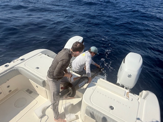
Last week, we deployed our latest infiniTE™ Float off the coast of Florida—the first of its kind in the Gulf of Mexico to carry both a CTD sensor and a hydrophone (an underwater microphone). A CTD sensor measures conductivity (to calculate salinity), temperature, and depth, providing a detailed view of how warm water is distributed below the surface. That subsurface heat can fuel hurricanes to strengthen quickly. Satellites capture only surface conditions, but they cannot detect the deeper layers of warm water linked to rapid intensification. As tropical storms approach the Gulf, the float will profile subsurface layers every six hours, providing data to help improve intensity forecasts. At the same time, the hydrophone will collect acoustic information for soundscape monitoring to support marine conservation, particularly for the critically endangered Rice's whales.
Building on success in Hawai'i and expanding partnerships
This summer, our Persistent Smart Acoustic Profiler (PSAP)—a SEATREC infiniTE™ Float developed in collaboration with the Naval Postgraduate School (NPS)—reached a milestone of 1,000 dives to depths of 700 meters.
Launched off the coast of Kona, Hawai‘i in November 2024, the PSAP carried a CTD sensor and a passive acoustic hydrophone, processed data onboard, and transmitted results in real time. Powered entirely by SEATREC’s patented thermal energy harvesting system, it generated more electricity than it consumed, harvesting over 10 megajoules (2,800 Wh) in just seven months—more than twice the energy of a conventional battery-powered float.
NPS’s interest in this effort was clear. Persistent, real-time ocean intelligence is critical for missions such as undersea warfare and maritime domain awareness, and the PSAP platform demonstrated that it could deliver both oceanographic and acoustic data without relying on external assets. It also provided valuable datasets for METOC program students, linking applied research with Navy readiness.
The success of PSAP in Hawai‘i validated the endurance and self-powering capability of the platform. It also proved that long-term, multi-sensor ocean monitoring is achievable. With that foundation in place, our next step was to expand the mission into the Gulf of Mexico, where hurricane intensification and the habitat of the Rice’s whales present urgent challenges for science, conservation, and coastal resilience
What makes this float different

Building on the PSAP's design, this infiniTE™ Float carries a suite of sensors and capabilities tailored to both hurricane forecasting and marine life monitoring:
- CTD sensor — measures conductivity (salinity), temperature, and depth to profile ocean conditions throughout hurricane season
- Hydrophone with onboard processing — captures and analyzes underwater soundscapes in near real time
- Remote reconfiguration — allows the system to focus on detecting Rice’s whale vocalizations for targeted acoustic tracking within their federally designated critical habitat in the Gulf of Mexico.
Diving deep, surfacing more frequently

Every six hours, the float dives to as deep as 800 meters, collects data, and resurfaces to transmit a snapshot of the ocean’s physical state. The data reveal how warm water is layered below the surface—conditions linked to rapid hurricane intensification. Each profile adds new observations of the Gulf’s subsurface and provides inputs that forecasters can use in intensity models.
Why it matters
This mission bridges science, technology, and conservation:
- For coastal communities: better hurricane forecasts and more lead time to prepare.
- For researchers: more oceanographic data that deepens understanding of ocean-atmosphere interactions.
- For marine life: acoustic monitoring that supports conservation of critically endangered species such as Rice’s whales.
SEATREC’s vision is to harvest the ocean’s natural energy gradients to power smarter, longer-lasting ocean drones and power systems. This deployment in the Gulf is another step toward that future
Follow along
We’ll be sharing more from this mission as the float continues its journey. Stay tuned as real-time ocean data shape the way we forecast hurricanes and protect marine life.