
The North American Gulf Stream as illustrated with the ECCO model.
Credit: Greg Shirah / NASA’s Scientific Visualization Studio
From “How Far from Reality?” to Real-Time Ocean Observation
How Seatrec CEO Yi Chao’s early Gulf Stream research comes full circle in an infiniTE™ Float mission now more than 500 profiles in, from the Gulf of Mexico to the western North Atlantic
Three decades ago, long before Seatrec existed, our CEO and founder, Yi Chao, was working on one of the hardest problems in physical oceanography: how to model the Gulf Stream realistically as it separates from the U.S. coast near Cape Hatteras. Today, a Seatrec infiniTE™ float is tracing that broader Atlantic system in the real ocean, more than 500 profiles into a mission spanning the Gulf of Mexico, the Florida Straits, and the western North Atlantic.

That connection is more than a coincidence. It is the throughline of Yi’s career. During his Ph.D. at Princeton, Yi studied El Niño. After graduate school, he turned to the Gulf Stream because one question kept bothering oceanographers: why couldn’t models reproduce its separation correctly at Cape Hatteras? For years, that gap was more than a technical frustration. It suggested that even advanced ocean models were still missing something essential about North Atlantic circulation.
In 1996, while at NASA’s Jet Propulsion Laboratory, Yi co-authored “Modeling the Gulf Stream System: How Far from Reality?” The paper marked an important advance in showing that the Gulf Stream could be modeled much more realistically than before. It was one of Yi’s earliest papers at JPL and helped establish a question that would shape much of his career.
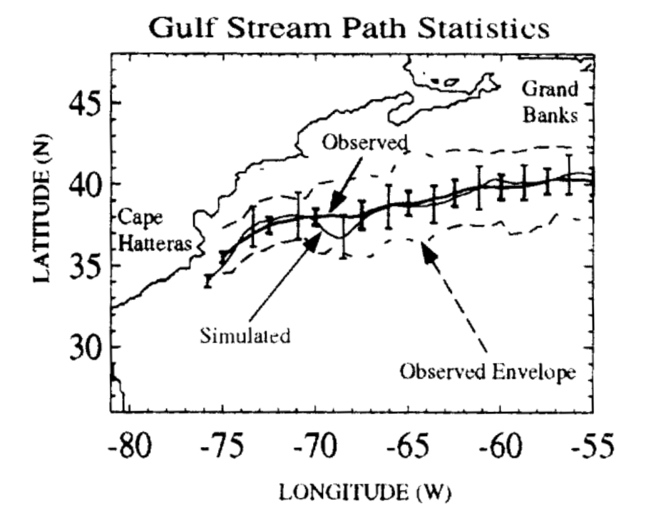
The title of that paper still resonates with us: How far from reality? In many ways, that question sits at the heart of Seatrec. Yi went on to spend roughly 20 years at NASA Jet Propulsion Laboratory working in ocean modeling and satellite oceanography before founding Seatrec in 2016. Our core technology originated at NASA JPL / Caltech, and our mission is to make the ocean more continuously observable by solving one of subsea science’s most stubborn constraints: power.
For decades, oceanographers have had to make difficult tradeoffs. Traditional profiling floats are constrained by primary batteries, which limit mission duration, sampling frequency, and payload flexibility. Satellites transformed our view of the surface ocean, but the subsurface ocean, the heat structure, salinity gradients, mixing, and soundscape, remains much harder to observe persistently. That is the gap Seatrec was built to close.
Seatrec’s answer has been to rethink power from the ocean up. Our infiniTE™ platform harvests electricity from naturally occurring temperature differences between warm surface water and colder depths. As the float cycles through the water column, phase-change materials drive a hydraulic system and generator, producing power for repeated profiling and expanded sensing. The result is a long-endurance platform designed to collect more data, more often, with less dependence on battery replacement and ship support.
This 500-profile mission shows what that looks like in practice. The mission began in the northeastern Gulf of Mexico, south of Destin, Florida. In its first 49 days, the float completed 160 profiles, diving to depths of up to 800 meters while surfacing to transmit real-time data. Equipped with a CTD and passive acoustic hydrophone, it began building a continuous picture of subsurface temperature, salinity, and underwater sound in a region where seeing below the surface matters for both hurricane forecasting and soundscape monitoring.
After 315 profiles, the float entered the Florida Straits, where the mission shifted from broad Gulf drifting to boundary-current sampling. This narrow, deep, high-energy corridor between the Florida Keys and Cuba funnels flow toward the Atlantic and sharpens vertical and horizontal gradients. In this phase, the float was completing about four profiles per day, creating a much denser record of changing subsurface conditions through one of the most dynamic passages in the western Atlantic.
By 480 profiles, the mission had advanced from the Gulf of Mexico through the Florida Straits, up the U.S. East Coast, setting up the next chapter as the float entered the Gulf Stream separation region off Cape Hatteras, the same broader system that defined an early chapter of Yi’s scientific career. What once lived in model grids is now being sampled profile by profile by an autonomous float powered by the ocean’s own thermal gradients.
That is why this milestone feels bigger than a number. Yes, 500 profiles is an operational achievement. But it is also a reminder that the best ocean technology does more than last longer. It changes what is scientifically possible. Seatrec’s milestone is not that this is the first float to sample the Gulf Stream. It is that a thermally powered float is delivering persistent, high-frequency profiling across multiple connected ocean regimes, without the same battery limits that have historically constrained mission duration and sensor use.
Persistent subsurface measurements help reveal the hidden heat structure that can fuel hurricane rapid intensification. They support better understanding of ocean heat transport and water-column structure across connected current systems. And when acoustic sensing is added to the same long-endurance platform, they can also contribute to persistent soundscape monitoring.
For Seatrec, this is a field report. For Yi, it is a full-circle moment. Three decades after asking how far ocean models were from reality, he now leads a company building tools that can stay in that reality longer, profiling through it, transmitting from it, and helping make the ocean more continuously observable. Few scientific careers draw such a direct line from question to platform. This one does.
And the float is still going.
Live tracking: seatrec-floats.com
Data access and collaboration: info@seatrec.com