

Seatrec’s infiniTE™ Profiling Float Captures First-of-Its-Kind Fine-Scale Ocean Vertical Structure
Seatrec’s infiniTE™ Profiling Float Captures First-of-Its-Kind Fine-Scale Ocean Vertical Structure, Powered by Temperature Gradients
A serendipitous meeting between ocean engineers and scientists sparked a new float mission to change how the ocean is measured
VISTA, Calif.— Feb. 23, 2026 — Seatrec, a leader in thermal-powered, long-endurance subsea drones, today announced the successful launch of a collaborative scientific mission to develop new autonomous profiling float capabilities that are powered by the ocean’s temperature differences and collect critical data on ocean health and carbon cycling.
This mission originated from a booth conversation at the American Geophysical Union (AGU)-sponsored Ocean Sciences Meeting 2024 (OSM24), held in New Orleans in February 2024. Seatrec CEO and Founder, Yi Chao, Ph.D., met with Mark Altabet, Ph.D, Professor and Chair of the School for Marine Science & Technology at the University of Massachusetts Dartmouth, and Eric A. D’Asaro, Ph.D., Senior Principal Oceanographer of the Applied Physics Laboratory and School of Oceanography at the University of Washington. At the time, Seatrec had recently launched its commercial infiniTE™ float. During discussions, Altabet and D’Asaro explored how the infiniTE float could fundamentally alter sampling strategies for studying turbulence, internal waves, and ocean mixing. That discussion marked the beginning of a co-development effort.
“Data below the ocean surface is significantly lacking because traditional profiling floats are all powered by primary batteries that limit float life and data collection capability,” explained Chao. “The infiniTE float harvests energy from temperature gradients in the ocean, and can therefore collect more frequent measurements and carry new sensors.”
The collaboration resulted in the successful development and deployment of an infiniTE float with two sensors to measure oxygen and total dissolved gas pressure (TDGP), key indicators of ecosystem health, environmental stress, and carbon cycling. The accurate measurement of TDGP requires the float to park at multiple depths and remain at each depth long enough for the sensor to collect reliable measurements.
“This type of mission has never been done before with the existing float products,” said D’Asaro. “The infiniTE float changes the way we think about power in a profiling float. In a battery-powered float, the total energy is fixed, so you try to minimize power usage by minimizing the number of profiles. Since the infiniTE float recharges its battery with the energy harvested from the ocean, there is no power penalty for more profiles.”
“Looking into the future,” said Altabet, “the infiniTE float can be used to profile more rapidly to resolve the diurnal variation of oxygen and its impact on productivity. This could only be done with the infiniTE float in a sustained way.”
This mission builds on Seatrec’s broader efforts to advance long-duration autonomous ocean systems, including a Cooperative Research and Development Agreement (CRADA) with the Naval Postgraduate School focused on enabling persistent, real-time oceanographic and acoustic measurements in open-ocean environments.
Related to this work, Chao will present at this week’s AGU Ocean Sciences Meeting in Glasgow, Scotland, on harvesting energy from ocean temperature gradients to power underwater robots and sensors for persistent monitoring.
About Seatrec
Seatrec designs and manufactures subsea drones that generate electricity from ocean temperature gradients. Our products empower defense and oceanographic researchers to extend mission durations, optimize data collection, and reduce operational costs. By enabling the integration of advanced sensors previously limited in endurance and functionality, such as hydrophones, we open new possibilities for ocean science.
Seatrec’s energy-harvesting core technology was developed at NASA’s Jet Propulsion Laboratory and spun out of the California Institute of Technology in 2016. Seatrec is headquartered in Vista, California. Visit us at seatrec.com.
About the School for Marine Science & Technology, University of Massachusetts Dartmouth
The School for Marine Science & Technology at the University of Massachusetts Dartmouth (SMAST) is a nationally and internationally recognized institution for education and research in marine science and ocean technology. SMAST is a collaborative community of dedicated students and expert faculty working together to address critical challenges in marine science while fostering a supportive and collegial environment. SMAST students and faculty help address urgent issues facing the world’s oceans, including climate change and ocean impacts, food security via sustainable fisheries, sustainable energy development and associated impacts, and coastal ecosystem resilience.
About the Applied Physics Laboratory, University of Washington
The University of Washington Applied Physics Laboratory (APL-UW) was founded by the U.S. Navy in 1943 to conduct acoustic and oceanographic studies on how deep ocean variability affects Navy systems. Today, APL-UW scientists and engineers lead research and applied technologies in acoustic and remote sensing, ocean physics and engineering, medical and industrial ultrasound, polar science and logistics, environmental and information systems, and electronic and photonic systems.
Media Contact
Marta Bulaich
Seatrec, Inc.
marta.bulaich@seatrec.com
+1 (415) 816-1665

Seatrec infiniTE™ Gulf Mission Update: 315 Profiles — Now in the Florida Straits
Seatrec infiniTE™ Gulf Mission Update: 315 Profiles — Now in the Florida Straits
Since our last update on November 4, the infiniTE™ float has completed 155 additional profiles and is now entering the Florida Straits, a narrow, high-energy corridor between the Florida Keys and Cuba where Gulf waters accelerate toward the Atlantic. The straits present markedly different sampling conditions: sharp frontal boundaries between water masses and rapidly varying subsurface structure to 800 m depth.
Current mission totals
-
Profiles completed: 315
-
Profiling depth: 800 meters
-
Total Energy harvested: 2.609 MJ
-
Sampling interval: ~every 6 hours
-
Data transmission: near real-time via satellite after each surfacing

The Florida Straits sampling context
The Florida Straits form a narrow, deep passage connecting the Gulf of Mexico to the Atlantic Ocean between the Florida Keys and Cuba, concentrating both flow and vertical structure over a short horizontal scale.
Geometry: At the narrowest point, the straits are ~93 miles (150 km) wide yet exceed 1,800 m in depth, creating a confined deep channel between shallow coastal shelves. This geometry funnels flow and steepens horizontal and vertical gradients in temperature and velocity.
The Florida Current: The Florida Current accelerates as it exits the Gulf, with mean surface velocities of 4–6 mph (6.5–9.5 km/h). These speeds increase horizontal advection between profiles and sharpen frontal boundaries encountered during repeated sampling.
Long-term monitoring: Current transport through the straits has been monitored nearly continuously since 1982 by NOAA's Atlantic Oceanographic and Meteorological Laboratory, producing over 14,000 daily transport estimates. This long record provides a well-characterized dynamical context for new subsurface observations.
From Gulf drifting to boundary-current sampling
For its first 315 profiles, the float drifted across the Gulf of Mexico, building a broad picture of subsurface temperature and salinity conditions.
In the Florida Straits, the situation changes. Strong currents carry the float tens of kilometers between profiles, and water properties can change quickly over short distances. This means each profile reflects not only changes over time, but also differences from one location to the next.
Compared with the interior Gulf, these faster currents and sharper boundaries make the Florida Straits a more challenging environment to sample and interpret, requiring frequent, repeated measurements.
What’s being measured every cycle
Every ~6 hours the float dives, profiles, surfaces, and transmits data.
CTD (Conductivity–Temperature–Depth): Profiles salinity and temperature through the upper ocean to reveal layering, mixing, and subsurface heat structure—information satellites cannot observe.
Hydrophone: Records the underwater soundscape. Onboard processing compresses acoustic data for near-real-time transmission via satellite.
How it’s powered (no battery replacement required)
infiniTE™ is powered by Seatrec’s thermal energy harvesting system using phase-change materials (PCMs). As the float cycles between warm surface water and cold deep water, the PCM expands and contracts during phase transition, driving a hydraulic system and generator to produce electricity.
This enables sustained operation at approximately four profiles per day over multi-month deployments without battery replacement.
Collaboration opportunities
Seatrec is seeking collaborators focused on:
- Subsurface heat transport and model validation
- Gulf/Florida Straits soundscape ecology
- Long-duration autonomous sensing
Interested in data access or deploying similar technology? Contact info@seatrec.com.

Gulf of Mexico Ocean Monitoring: 160 Profiles in 49 Days
Gulf of Mexico Ocean Monitoring: 160 Profiles in 49 Days and Counting
In just 49 days, Seatrec’s autonomous infiniTE™ float has successfully completed 160 profiles, powered entirely by the ocean’s temperature differences. Built for endurance, the float continues to dive, surface, and transmit real-time data without a single battery swap. This proves how thermal energy harvesting enables truly persistent ocean monitoring in one of the world’s most dynamic marine environments.
Mission Success in the Gulf
Deployed in the northeastern Gulf, south of Destin, Florida, the float has been transmitting continuous data below the surface. This information provides critical insight for understanding this region.
By the Numbers
- Profiles: 160 reaching depths of up to 800 meters
- Energy: 1.241 megajoules of thermal energy generated from the ocean
- Data: Real-time data transmitted after each surfacing
- Trajectory: Drifted hundreds of kilometers to the southwest
What the Float Does
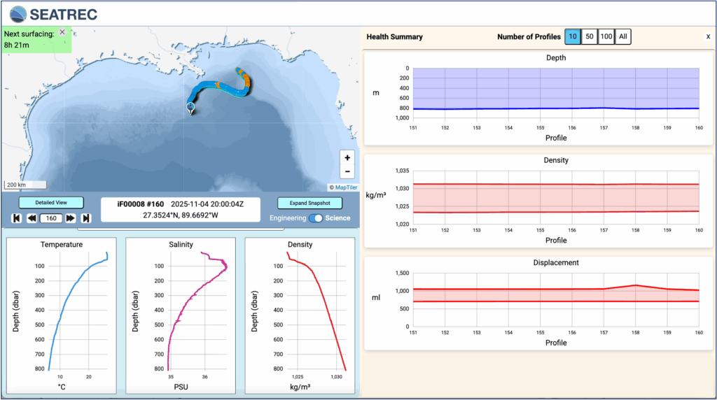
Every eight hours, the float collects CTD and acoustic data, surfaces, and transmits results.
- CTD sensor: Measures conductivity (salinity), temperature, and depth—revealing how heat and water masses
layer beneath the surface. These are key inputs for ocean and climate models. - Hydrophone: Records underwater soundscapes, with onboard processing of the recorded data to reduce file size for real-time transmission via satellite.
All of this is powered by Seatrec’s patented thermal energy harvesting system, which converts the temperature differences between surface and deep water into electricity.
Power Generation: Seatrec’s patented technology uses phase-change materials (PCMs) that transition from solid to liquid (SL). When PCMs experience temperature changes, they undergo a phase transition and change volume. This volume change drives a motor through pressurized fluid, converting hydraulic energy into electricity. During the warming phase (left), the contained working substance changes from solid to liquid, expands, and generates pressure that forces hydraulic oil through a generator to produce electrical energy. During the cooling phase (right), the working substance freezes and contracts.
Record Atlantic Hurricane Season, Quiet Gulf Waters, But Much to Listen to
The 2025 Atlantic hurricane season has been one of the most active on record, with 13 named storms, four major hurricanes, and three Category 5 systems. Hurricane Melissa became one of the strongest Atlantic hurricanes ever recorded.
Yet the Gulf of Mexico has remained unusually quiet. While our float hasn’t yet profiled Gulf waters during an active hurricane, it is building the baseline subsurface thermal data that forecasters need before the next storm forms.
The Rapid Intensification Challenge
This year underscored a growing forecasting challenge: rapid intensification — the explosive strengthening of storms fueled by ocean heat. Three Category 5 hurricanes formed this season, each undergoing rapid strengthening that caught forecasters and communities off guard.
Hurricane Melissa exemplified this trend. According to National Hurricane Center advisories, Melissa intensified from a tropical storm to a 140 mph Category 4 in roughly 24 hours, then continued to 175 mph Category 5 strength with a minimum pressure of 906 millibars, making landfall in Jamaica as one of the strongest Atlantic hurricanes ever recorded. Hurricanes Erin and Humberto also showed similar surges, driven by ocean heat content.
Ocean Heat: The Hidden Fuel
Rapid intensification requires specific conditions:
- High humidity
- Low wind shear
- Deep pools of warm water
It is not just surface temperature that matters; it is how deep that warmth extends. A hurricane moving over high ocean heat content taps into a massive energy reservoir, enabling the explosive strengthening that makes these storms so dangerous.
Why This Float’s Data Matters
Understanding where and when these pools of warm water exist is essential for forecasting rapid intensification. Traditional ship-based surveys cannot provide continuous coverage, and satellites only measure surface temperature. That is where autonomous floats like Seatrec’s become invaluable. Profiling temperature and salinity to 800 meters every eight hours, our infiniTE™ float maps the three-dimensional heat structure of the Gulf — the hidden energy that fuels storms.
These data will help researchers:
- Identify regions of high ocean heat content where rapid intensification is most likely
- Understand seasonal and interannual variability in Gulf heat content
- Validate and improve hurricane forecast models
As forecasters aim to improve rapid-intensification predictions by even 5–7 percent, this type of continuous data collection will be essential.
Partner With Us
Whether major storms arrive this year or not, Seatrec is delivering on its promise: autonomous, self-powered ocean monitoring that provides continuous data for better forecasts, deeper understanding, and more effective conservation.
We are always seeking collaborators interested in:
- Hurricane rapid-intensification research
- Gulf soundscape ecology and marine-mammal behavior
- Long-duration autonomous sensing in the region
Interested in accessing data or deploying similar technology for your research? Contact us at info@seatrec.com.
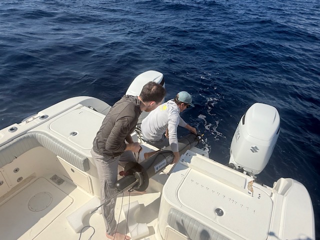
First Hydrophone-Equipped Float Deployed in the Gulf of Mexico
Advancing hurricane forecasts and protecting Rice’s whales
Last week, we deployed our latest infiniTE™ Float off the coast of Florida—the first of its kind in the Gulf of Mexico to carry both a CTD sensor and a hydrophone (an underwater microphone). A CTD sensor measures conductivity (to calculate salinity), temperature, and depth, providing a detailed view of how warm water is distributed below the surface. That subsurface heat can fuel hurricanes to strengthen quickly. Satellites capture only surface conditions, but they cannot detect the deeper layers of warm water linked to rapid intensification. As tropical storms approach the Gulf, the float will profile subsurface layers every six hours, providing data to help improve intensity forecasts. At the same time, the hydrophone will collect acoustic information for soundscape monitoring to support marine conservation, particularly for the critically endangered Rice's whales.
Building on success in Hawai'i and expanding partnerships
This summer, our Persistent Smart Acoustic Profiler (PSAP)—a SEATREC infiniTE™ Float developed in collaboration with the Naval Postgraduate School (NPS)—reached a milestone of 1,000 dives to depths of 700 meters.
Launched off the coast of Kona, Hawai‘i in November 2024, the PSAP carried a CTD sensor and a passive acoustic hydrophone, processed data onboard, and transmitted results in real time. Powered entirely by SEATREC’s patented thermal energy harvesting system, it generated more electricity than it consumed, harvesting over 10 megajoules (2,800 Wh) in just seven months—more than twice the energy of a conventional battery-powered float.
NPS’s interest in this effort was clear. Persistent, real-time ocean intelligence is critical for missions such as undersea warfare and maritime domain awareness, and the PSAP platform demonstrated that it could deliver both oceanographic and acoustic data without relying on external assets. It also provided valuable datasets for METOC program students, linking applied research with Navy readiness.
The success of PSAP in Hawai‘i validated the endurance and self-powering capability of the platform. It also proved that long-term, multi-sensor ocean monitoring is achievable. With that foundation in place, our next step was to expand the mission into the Gulf of Mexico, where hurricane intensification and the habitat of the Rice’s whales present urgent challenges for science, conservation, and coastal resilience
What makes this float different

Building on the PSAP's design, this infiniTE™ Float carries a suite of sensors and capabilities tailored to both hurricane forecasting and marine life monitoring:
- CTD sensor — measures conductivity (salinity), temperature, and depth to profile ocean conditions throughout hurricane season
- Hydrophone with onboard processing — captures and analyzes underwater soundscapes in near real time
- Remote reconfiguration — allows the system to focus on detecting Rice’s whale vocalizations for targeted acoustic tracking within their federally designated critical habitat in the Gulf of Mexico.
Diving deep, surfacing more frequently

Every six hours, the float dives to as deep as 800 meters, collects data, and resurfaces to transmit a snapshot of the ocean’s physical state. The data reveal how warm water is layered below the surface—conditions linked to rapid hurricane intensification. Each profile adds new observations of the Gulf’s subsurface and provides inputs that forecasters can use in intensity models.
Why it matters
This mission bridges science, technology, and conservation:
- For coastal communities: better hurricane forecasts and more lead time to prepare.
- For researchers: more oceanographic data that deepens understanding of ocean-atmosphere interactions.
- For marine life: acoustic monitoring that supports conservation of critically endangered species such as Rice’s whales.
SEATREC’s vision is to harvest the ocean’s natural energy gradients to power smarter, longer-lasting ocean drones and power systems. This deployment in the Gulf is another step toward that future
Follow along
We’ll be sharing more from this mission as the float continues its journey. Stay tuned as real-time ocean data shape the way we forecast hurricanes and protect marine life.