Seatrec infiniTE™ Gulf Mission Update: 315 Profiles — Now in the Florida Straits
Since our last update on November 4, the infiniTE™ float has completed 155 additional profiles and is now entering the Florida Straits, a narrow, high-energy corridor between the Florida Keys and Cuba where Gulf waters accelerate toward the Atlantic. The straits present markedly different sampling conditions: sharp frontal boundaries between water masses and rapidly varying subsurface structure to 800 m depth.
Current mission totals
-
Profiles completed: 315
-
Profiling depth: 800 meters
-
Total Energy harvested: 2.609 MJ
-
Sampling interval: ~every 6 hours
-
Data transmission: near real-time via satellite after each surfacing

The Florida Straits sampling context
The Florida Straits form a narrow, deep passage connecting the Gulf of Mexico to the Atlantic Ocean between the Florida Keys and Cuba, concentrating both flow and vertical structure over a short horizontal scale.
Geometry: At the narrowest point, the straits are ~93 miles (150 km) wide yet exceed 1,800 m in depth, creating a confined deep channel between shallow coastal shelves. This geometry funnels flow and steepens horizontal and vertical gradients in temperature and velocity.
The Florida Current: The Florida Current accelerates as it exits the Gulf, with mean surface velocities of 4–6 mph (6.5–9.5 km/h). These speeds increase horizontal advection between profiles and sharpen frontal boundaries encountered during repeated sampling.
Long-term monitoring: Current transport through the straits has been monitored nearly continuously since 1982 by NOAA's Atlantic Oceanographic and Meteorological Laboratory, producing over 14,000 daily transport estimates. This long record provides a well-characterized dynamical context for new subsurface observations.
From Gulf drifting to boundary-current sampling
For its first 315 profiles, the float drifted across the Gulf of Mexico, building a broad picture of subsurface temperature and salinity conditions.
In the Florida Straits, the situation changes. Strong currents carry the float tens of kilometers between profiles, and water properties can change quickly over short distances. This means each profile reflects not only changes over time, but also differences from one location to the next.
Compared with the interior Gulf, these faster currents and sharper boundaries make the Florida Straits a more challenging environment to sample and interpret, requiring frequent, repeated measurements.
What’s being measured every cycle
Every ~6 hours the float dives, profiles, surfaces, and transmits data.
CTD (Conductivity–Temperature–Depth): Profiles salinity and temperature through the upper ocean to reveal layering, mixing, and subsurface heat structure—information satellites cannot observe.
Hydrophone: Records the underwater soundscape. Onboard processing compresses acoustic data for near-real-time transmission via satellite.
How it’s powered (no battery replacement required)
infiniTE™ is powered by Seatrec’s thermal energy harvesting system using phase-change materials (PCMs). As the float cycles between warm surface water and cold deep water, the PCM expands and contracts during phase transition, driving a hydraulic system and generator to produce electricity.
This enables sustained operation at approximately four profiles per day over multi-month deployments without battery replacement.
Collaboration opportunities
Seatrec is seeking collaborators focused on:
- Subsurface heat transport and model validation
- Gulf/Florida Straits soundscape ecology
- Long-duration autonomous sensing
Interested in data access or deploying similar technology? Contact info@seatrec.com.
Related Content
- Gulf of Mexico Ocean Monitoring: 160 Profiles in 49 Days
- First Hydrophone-Equipped Float Deployed in the Gulf of Mexico
- NASA spinoff Seatrec offers a new power source for underwater robots
- Hawaii Mission Success: 1,000 Profiles — Thermal Energy Harvesting Validated
- Seatrec and Naval Postgraduate School Achieve Historic First with Real-Time Acoustic Data Collection
Gulf of Mexico Ocean Monitoring: 160 Profiles in 49 Days
Gulf of Mexico Ocean Monitoring: 160 Profiles in 49 Days and Counting
In just 49 days, Seatrec’s autonomous infiniTE™ float has successfully completed 160 profiles, powered entirely by the ocean’s temperature differences. Built for endurance, the float continues to dive, surface, and transmit real-time data without a single battery swap. This proves how thermal energy harvesting enables truly persistent ocean monitoring in one of the world’s most dynamic marine environments.
Mission Success in the Gulf
Deployed in the northeastern Gulf, south of Destin, Florida, the float has been transmitting continuous data below the surface. This information provides critical insight for understanding this region.
By the Numbers
- Profiles: 160 reaching depths of up to 800 meters
- Energy: 1.241 megajoules of thermal energy generated from the ocean
- Data: Real-time data transmitted after each surfacing
- Trajectory: Drifted hundreds of kilometers to the southwest
What the Float Does

Every eight hours, the float collects CTD and acoustic data, surfaces, and transmits results.
- CTD sensor: Measures conductivity (salinity), temperature, and depth—revealing how heat and water masses
layer beneath the surface. These are key inputs for ocean and climate models. - Hydrophone: Records underwater soundscapes, with onboard processing of the recorded data to reduce file size for real-time transmission via satellite.
All of this is powered by Seatrec’s patented thermal energy harvesting system, which converts the temperature differences between surface and deep water into electricity.
Power Generation: Seatrec’s patented technology uses phase-change materials (PCMs) that transition from solid to liquid (SL). When PCMs experience temperature changes, they undergo a phase transition and change volume. This volume change drives a motor through pressurized fluid, converting hydraulic energy into electricity. During the warming phase (left), the contained working substance changes from solid to liquid, expands, and generates pressure that forces hydraulic oil through a generator to produce electrical energy. During the cooling phase (right), the working substance freezes and contracts.
Record Atlantic Hurricane Season, Quiet Gulf Waters, But Much to Listen to
The 2025 Atlantic hurricane season has been one of the most active on record, with 13 named storms, four major hurricanes, and three Category 5 systems. Hurricane Melissa became one of the strongest Atlantic hurricanes ever recorded.
Yet the Gulf of Mexico has remained unusually quiet. While our float hasn’t yet profiled Gulf waters during an active hurricane, it is building the baseline subsurface thermal data that forecasters need before the next storm forms.
The Rapid Intensification Challenge
This year underscored a growing forecasting challenge: rapid intensification — the explosive strengthening of storms fueled by ocean heat. Three Category 5 hurricanes formed this season, each undergoing rapid strengthening that caught forecasters and communities off guard.
Hurricane Melissa exemplified this trend. According to National Hurricane Center advisories, Melissa intensified from a tropical storm to a 140 mph Category 4 in roughly 24 hours, then continued to 175 mph Category 5 strength with a minimum pressure of 906 millibars, making landfall in Jamaica as one of the strongest Atlantic hurricanes ever recorded. Hurricanes Erin and Humberto also showed similar surges, driven by ocean heat content.
Ocean Heat: The Hidden Fuel
Rapid intensification requires specific conditions:
- High humidity
- Low wind shear
- Deep pools of warm water
It is not just surface temperature that matters; it is how deep that warmth extends. A hurricane moving over high ocean heat content taps into a massive energy reservoir, enabling the explosive strengthening that makes these storms so dangerous.
Why This Float’s Data Matters
Understanding where and when these pools of warm water exist is essential for forecasting rapid intensification. Traditional ship-based surveys cannot provide continuous coverage, and satellites only measure surface temperature. That is where autonomous floats like Seatrec’s become invaluable. Profiling temperature and salinity to 800 meters every eight hours, our infiniTE™ float maps the three-dimensional heat structure of the Gulf — the hidden energy that fuels storms.
These data will help researchers:
- Identify regions of high ocean heat content where rapid intensification is most likely
- Understand seasonal and interannual variability in Gulf heat content
- Validate and improve hurricane forecast models
As forecasters aim to improve rapid-intensification predictions by even 5–7 percent, this type of continuous data collection will be essential.
Partner With Us
Whether major storms arrive this year or not, Seatrec is delivering on its promise: autonomous, self-powered ocean monitoring that provides continuous data for better forecasts, deeper understanding, and more effective conservation.
We are always seeking collaborators interested in:
- Hurricane rapid-intensification research
- Gulf soundscape ecology and marine-mammal behavior
- Long-duration autonomous sensing in the region
Interested in accessing data or deploying similar technology for your research? Contact us at info@seatrec.com.
Related Articles
Seatrec Launches Initiative to Boost Cost-Effective Seafloor Mapping
Seatrec Launches Initiative to Boost Cost-Effective Seafloor Mapping by Developing Autonomous Echosounder Float Powered by Ocean’s Temperature Differences
Project funded by Schmidt Marine Technology Partners brings seafloor mapping dream team together with transformative and sustainable tech to map the 80% of ocean bottom still uncharted at high-resolution
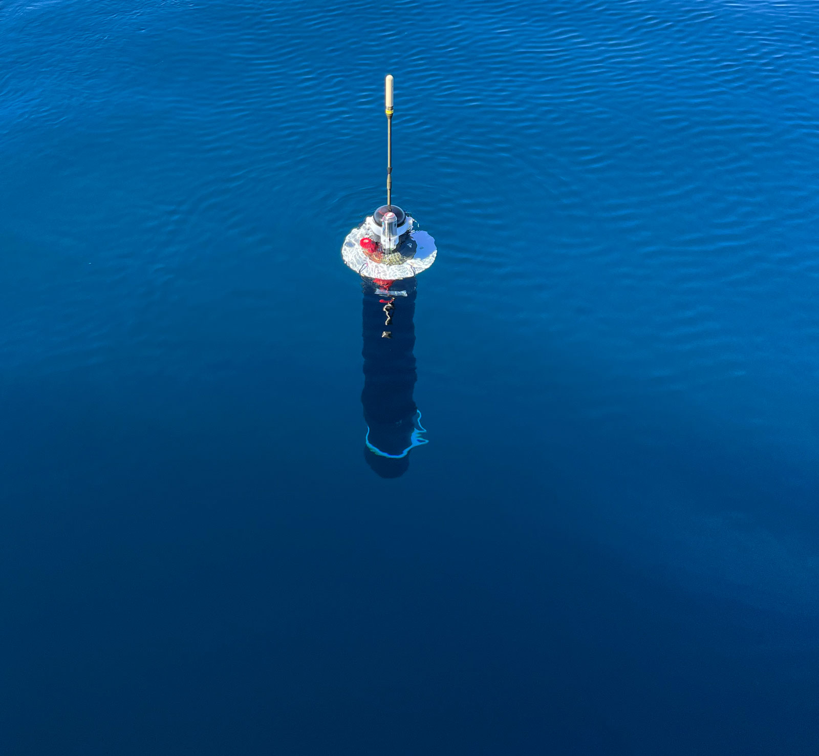
VISTA, Calif. (Oct. 27, 2021) – Seatrec, a renewable energy company that harvests energy from temperature differences in the environment, today launches a project to develop an autonomous echosounder float powered by clean, sustainable energy. With funding from Schmidt Marine Technology Partners, a program of the Schmidt Family Foundation founded by Wendy and Eric Schmidt, Seatrec will provide the float and power system while New Hampshire-based Airmar Technology Corporation, in collaboration with Innomar Technologie GmbH based in Germany, will provide the active acoustic echosounder for high-resolution mapping.
“Eighty percent of the seafloor has not been mapped at high-resolution - an area roughly twice the size of Mars - and covering an area that large using ships and today’s state-of-the-art autonomous platforms will cost billions of dollars,” explains Yi Chao, CEO and Founder of Seatrec. “This initiative brings together a seafloor mapping dream team with the transformative technology needed to create a sustainably powered method for mapping the ocean floor for a fraction of the cost compared to ships.”
The project is led by Larry Mayer, a professor and Director of the Center for Coastal and Ocean Mapping at the University of New Hampshire.
“The ocean’s resources are critical to supporting and sustaining all life on Earth and it’s shocking how little we know about something as fundamental as the seafloor,” observes Mayer. “It’s imperative that we develop the next generation of ocean mapping technologies to support the international community’s unprecedented effort to finally map the seafloor at high-resolution -- there’s no time to lose.”
Indeed, the world is racing to map the seafloor to help manage living resources, improve marine navigation, and guide infrastructure construction, as well as better defining the impacts of current and future human activity. The Nippon Foundation-GEBCO Seabed 2030 Project is a first-of-its-kind international effort to facilitate the complete mapping of the seafloor by 2030 and is a major contribution to the UN Decade of Ocean Science for Sustainable Development (2021-2030).
However, two critical obstacles stand in the way of success: energy and cost.
Mapping the 80% gaps of the global seafloor will cost an estimated $3B using ships burning diesel fuel and emitting carbon dioxide into the atmosphere. A robotic revolution resulted in the growing use of autonomous vehicles to reduce the cost of using ships and the associated carbon footprint. Seatrec’s technology to harvest energy from the ocean thermal energy is transformative and provides a cost-effective and sustainable solution to deploy a fleet of subsea robots at a fraction of the cost of ships.
“Mapping the seafloor provides fundamental and critical data we need to protect the health of our oceans but such a massive undertaking requires innovative and sustainable solutions from the best and brightest,” points out Erika Montague, the Chief Technologist of the Schmidt Marine Technology Partners. “This initiative provides a path forward towards better understanding and protection of our ocean.”
About Seatrec
Seatrec designs and manufactures energy harvesting systems that generate electricity from naturally occurring temperature differences in ocean waters. This renewable energy can be used to power deep water oceanographic research equipment such as floats, gliders, and Autonomous Underwater Vehicles (AUVs), resulting in the most scalable, cost-effective deep ocean data collection possible. Incorporated in 2016 by CEO, Dr. Yi Chao, Seatrec’s technology originated at NASA Jet Propulsion Laboratory, California Institute of Technology, to provide clean power for remote off-grid locations. The company is headquartered in Vista, CA. Visit us at www.seatrec.com and @seatrecinc.
Media contact
Sean Yokomizo
+1 925.878.1200
Forbes Tech Council: Hurricanes Blow, But Our Forecasting Sucks
Our Founder and CEO, Yi Chao, is a member of the Forbes Technology Council. In his first contributed article, Yi addresses the challenges with hurricane forecasting.
2020 was an epic year for hurricanes with the most named storms on record. The rapid intensification of hurricanes, defined as a meteorological situation where a tropical cyclone intensifies dramatically in a short period of time, poses significant perils to coastal communities. Although hurricane forecasting has improved over the years, data problems abound with siloed data and a dearth of data below the ocean’s surface.
Read the article here.
Seatrec, Northrop Grumman Receive DARPA Award for Developing Deep Sea Robots to Study Climate Change and Support Blue Economy
Seatrec, Northrop Grumman Receive DARPA Award for Developing Deep Sea Robots That Can Study Climate Change and Support Blue Economy
Small Business Innovation Research Phase II is next step toward commercialization of fast-diving, autonomous robots that are powered by Aluminum fuel
Seatrec, a renewable energy company that harvests energy from temperature differences in the environment, announced today that it has been awarded a Phase II Small Business Innovation Research (SBIR) grant from the Defense Advanced Research Projects Agency (DARPA). As part of the grant, Seatrec has assembled a multi-disciplinary team of scientists and engineers and subcontracted Northrop Grumman to support the development of a float that can dive to 1000 meters at a speed of 1 meter per second, a factor of 10 faster than the current state-of-the-art.
Dr. Yi Chao, Founder and CEO of Seatrec, is the Principal Investigator on the grant and built the company’s technology he started at NASA’s Jet Propulsion Laboratory.
“Today’s buoyancy engines are too small to support such a fast profiling speed. If we increase the size of the buoyancy engine and add a propeller, the required 1 m/s speed can be achieved, however, a significantly larger battery would be necessary in order to maintain long endurance. We’re excited to partner with Professor Doug Hart from MIT to explore the use of aluminum fuel, when mixed with water, to create the extra buoyancy required to achieve a 10x increase of the profiling speed,” said Chao.
“Aluminum, long used as a solid rocket propellant, is among the most energy-dense materials known but has found little use in other applications due to difficulties in harnessing its power. My group at MIT has developed a method to safely create a liquid slurry that can be reacted with water on contact releasing hydrogen gas and heat. In this project, the hydrogen gas will be used to generate positive buoyancy to achieve an order of magnitude increase in profiling speed,” said Hart.
“Ocean data needs a sea change to help navigate the warming world,” stated in a recent article in Nature, “The ocean covers about 70 percent of Earth’s surface, regulates the climate and it’s home to countless species of fish, a major source of protein for more than one billion people. It is now under threat from climate change, overfishing and pollution.” This technological advancement will certainly accelerate the evolution of ocean observation and monitoring.
“There are simply no other energy harvesting solutions available like Seatrec. The synergy of these innovative technologies and our experience in developing military-grade solutions will result in a very promising offering to better observe our oceans,” said Brian Theobald, Chief Engineer for Northrop Grumman Undersea Systems.
About Seatrec
Seatrec designs and manufactures energy harvesting systems that generate electricity from naturally occurring temperature differences in ocean waters. This renewable energy can be used to power deep water oceanographic research equipment such as floats, gliders, and Autonomous Underwater Vehicles (AUVs), resulting in the most scalable, cost-effective deep ocean data collection possible. Incorporated in 2016 by CEO, Dr. Yi Chao, Seatrec’s technology originated at NASA Jet Propulsion Laboratory, California Institute of Technology, to provide clean power for remote off-grid locations. The company is headquartered in Monrovia, CA. Visit us at www.seatrec.com and @seatrecinc.
Media contact
Marta Bulaich
Head of Marketing
marta@seatrec.com
+1 415-816-1665
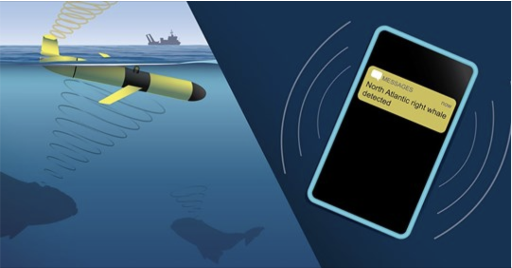
Teaming Up for Right Whales Using Gliders
Ocean gliders are able to detect multiple marine animals such as whales in near real-time. These gliders can be instrumental in preventing lethal ship strikes as endangered whales migrate through shipping lanes and fishing grounds. For example, when a glider detects a whale (or any species of interest), it can send a text message to scientists, regulators, and ships in the vicinity.
And, we're proud to note the cool shout out to our very own Dave Fratantoni. About 10 years ago, Dave worked on a digital acoustic monitoring device (#DMON), while working with WHOI scientists and engineers Mark Johnson, Jim Partan, et al.


