

Seatrec infiniTE™ Gulf Mission Update: 315 Profiles — Now in the Florida Straits
Seatrec infiniTE™ Gulf Mission Update: 315 Profiles — Now in the Florida Straits
Since our last update on November 4, the infiniTE™ float has completed 155 additional profiles and is now entering the Florida Straits, a narrow, high-energy corridor between the Florida Keys and Cuba where Gulf waters accelerate toward the Atlantic. The straits present markedly different sampling conditions: sharp frontal boundaries between water masses and rapidly varying subsurface structure to 800 m depth.
Current mission totals
-
Profiles completed: 315
-
Profiling depth: 800 meters
-
Total Energy harvested: 2.609 MJ
-
Sampling interval: ~every 6 hours
-
Data transmission: near real-time via satellite after each surfacing

The Florida Straits sampling context
The Florida Straits form a narrow, deep passage connecting the Gulf of Mexico to the Atlantic Ocean between the Florida Keys and Cuba, concentrating both flow and vertical structure over a short horizontal scale.
Geometry: At the narrowest point, the straits are ~93 miles (150 km) wide yet exceed 1,800 m in depth, creating a confined deep channel between shallow coastal shelves. This geometry funnels flow and steepens horizontal and vertical gradients in temperature and velocity.
The Florida Current: The Florida Current accelerates as it exits the Gulf, with mean surface velocities of 4–6 mph (6.5–9.5 km/h). These speeds increase horizontal advection between profiles and sharpen frontal boundaries encountered during repeated sampling.
Long-term monitoring: Current transport through the straits has been monitored nearly continuously since 1982 by NOAA's Atlantic Oceanographic and Meteorological Laboratory, producing over 14,000 daily transport estimates. This long record provides a well-characterized dynamical context for new subsurface observations.
From Gulf drifting to boundary-current sampling
For its first 315 profiles, the float drifted across the Gulf of Mexico, building a broad picture of subsurface temperature and salinity conditions.
In the Florida Straits, the situation changes. Strong currents carry the float tens of kilometers between profiles, and water properties can change quickly over short distances. This means each profile reflects not only changes over time, but also differences from one location to the next.
Compared with the interior Gulf, these faster currents and sharper boundaries make the Florida Straits a more challenging environment to sample and interpret, requiring frequent, repeated measurements.
What’s being measured every cycle
Every ~6 hours the float dives, profiles, surfaces, and transmits data.
CTD (Conductivity–Temperature–Depth): Profiles salinity and temperature through the upper ocean to reveal layering, mixing, and subsurface heat structure—information satellites cannot observe.
Hydrophone: Records the underwater soundscape. Onboard processing compresses acoustic data for near-real-time transmission via satellite.
How it’s powered (no battery replacement required)
infiniTE™ is powered by Seatrec’s thermal energy harvesting system using phase-change materials (PCMs). As the float cycles between warm surface water and cold deep water, the PCM expands and contracts during phase transition, driving a hydraulic system and generator to produce electricity.
This enables sustained operation at approximately four profiles per day over multi-month deployments without battery replacement.
Collaboration opportunities
Seatrec is seeking collaborators focused on:
- Subsurface heat transport and model validation
- Gulf/Florida Straits soundscape ecology
- Long-duration autonomous sensing
Interested in data access or deploying similar technology? Contact info@seatrec.com.

Gulf of Mexico Ocean Monitoring: 160 Profiles in 49 Days
Gulf of Mexico Ocean Monitoring: 160 Profiles in 49 Days and Counting
In just 49 days, Seatrec’s autonomous infiniTE™ float has successfully completed 160 profiles, powered entirely by the ocean’s temperature differences. Built for endurance, the float continues to dive, surface, and transmit real-time data without a single battery swap. This proves how thermal energy harvesting enables truly persistent ocean monitoring in one of the world’s most dynamic marine environments.
Mission Success in the Gulf
Deployed in the northeastern Gulf, south of Destin, Florida, the float has been transmitting continuous data below the surface. This information provides critical insight for understanding this region.
By the Numbers
- Profiles: 160 reaching depths of up to 800 meters
- Energy: 1.241 megajoules of thermal energy generated from the ocean
- Data: Real-time data transmitted after each surfacing
- Trajectory: Drifted hundreds of kilometers to the southwest
What the Float Does
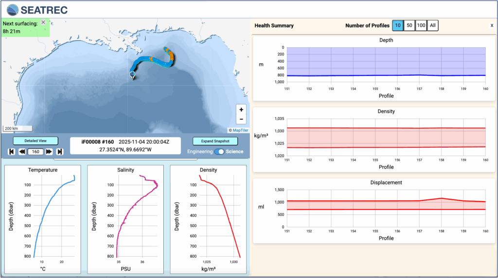
Every eight hours, the float collects CTD and acoustic data, surfaces, and transmits results.
- CTD sensor: Measures conductivity (salinity), temperature, and depth—revealing how heat and water masses
layer beneath the surface. These are key inputs for ocean and climate models. - Hydrophone: Records underwater soundscapes, with onboard processing of the recorded data to reduce file size for real-time transmission via satellite.
All of this is powered by Seatrec’s patented thermal energy harvesting system, which converts the temperature differences between surface and deep water into electricity.
Power Generation: Seatrec’s patented technology uses phase-change materials (PCMs) that transition from solid to liquid (SL). When PCMs experience temperature changes, they undergo a phase transition and change volume. This volume change drives a motor through pressurized fluid, converting hydraulic energy into electricity. During the warming phase (left), the contained working substance changes from solid to liquid, expands, and generates pressure that forces hydraulic oil through a generator to produce electrical energy. During the cooling phase (right), the working substance freezes and contracts.
Record Atlantic Hurricane Season, Quiet Gulf Waters, But Much to Listen to
The 2025 Atlantic hurricane season has been one of the most active on record, with 13 named storms, four major hurricanes, and three Category 5 systems. Hurricane Melissa became one of the strongest Atlantic hurricanes ever recorded.
Yet the Gulf of Mexico has remained unusually quiet. While our float hasn’t yet profiled Gulf waters during an active hurricane, it is building the baseline subsurface thermal data that forecasters need before the next storm forms.
The Rapid Intensification Challenge
This year underscored a growing forecasting challenge: rapid intensification — the explosive strengthening of storms fueled by ocean heat. Three Category 5 hurricanes formed this season, each undergoing rapid strengthening that caught forecasters and communities off guard.
Hurricane Melissa exemplified this trend. According to National Hurricane Center advisories, Melissa intensified from a tropical storm to a 140 mph Category 4 in roughly 24 hours, then continued to 175 mph Category 5 strength with a minimum pressure of 906 millibars, making landfall in Jamaica as one of the strongest Atlantic hurricanes ever recorded. Hurricanes Erin and Humberto also showed similar surges, driven by ocean heat content.
Ocean Heat: The Hidden Fuel
Rapid intensification requires specific conditions:
- High humidity
- Low wind shear
- Deep pools of warm water
It is not just surface temperature that matters; it is how deep that warmth extends. A hurricane moving over high ocean heat content taps into a massive energy reservoir, enabling the explosive strengthening that makes these storms so dangerous.
Why This Float’s Data Matters
Understanding where and when these pools of warm water exist is essential for forecasting rapid intensification. Traditional ship-based surveys cannot provide continuous coverage, and satellites only measure surface temperature. That is where autonomous floats like Seatrec’s become invaluable. Profiling temperature and salinity to 800 meters every eight hours, our infiniTE™ float maps the three-dimensional heat structure of the Gulf — the hidden energy that fuels storms.
These data will help researchers:
- Identify regions of high ocean heat content where rapid intensification is most likely
- Understand seasonal and interannual variability in Gulf heat content
- Validate and improve hurricane forecast models
As forecasters aim to improve rapid-intensification predictions by even 5–7 percent, this type of continuous data collection will be essential.
Partner With Us
Whether major storms arrive this year or not, Seatrec is delivering on its promise: autonomous, self-powered ocean monitoring that provides continuous data for better forecasts, deeper understanding, and more effective conservation.
We are always seeking collaborators interested in:
- Hurricane rapid-intensification research
- Gulf soundscape ecology and marine-mammal behavior
- Long-duration autonomous sensing in the region
Interested in accessing data or deploying similar technology for your research? Contact us at info@seatrec.com.